![]()
![]()
![]()
![]()
![]()
![]()
![]()
![]()
![]() Home > Space & Science
Home > Space & Science
Powerful GOES-T Satellite Launches To Eye Earth's Weather, Climate
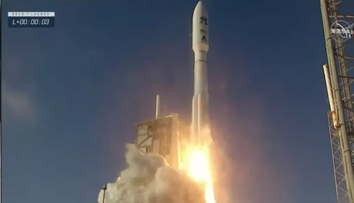
A United Launch Alliance Atlas V rocket launches NOAA's GOES-T satellite from Cape Canaveral Space Force Station on March 1, 2022. (Image credit: NASA TV)
![]() March 2nd, 2022 | 17:32 PM |
March 2nd, 2022 | 17:32 PM | ![]() 571 views
571 views
Space.com
An Atlas V rocket sent GOES-T skyward today (March 1).
Scientists will soon have a powerful new set of eyes in the sky to study Earth's weather and climate.
The GOES-T satellite lifted off from Florida's Cape Canaveral Space Force Station today (March 1) at 4:38 p.m. EST (2138 GMT), riding a United Launch Alliance (ULA) Atlas V rocket into the final frontier. GOES-T deployed as planned from the Atlas V's upper stage about 3.5 hours after liftoff, ULA representatives confirmed this evening via Twitter.
GOES-T is the latest spacecraft in the U.S. National Oceanic and Atmospheric Administration's (NOAA) $11.7 billion, four-satellite Geostationary Operational Environmental Satellite (GOES)-R series. The satellite is headed for geostationary orbit, about 22,300 miles (35,900 kilometers) above our planet.
GOES-T will do a variety of work from that perch, helping scientists keep tabs on weather systems and natural hazards across a broad stretch of the Western Hemisphere.
GOES-T will be renamed GOES-18 after reaching geostationary orbit. It will then begin a lengthy commissioning period.
"Initially, it will be placed at the longitude of 89.5 [degrees] west, which is for the central United States, where it will begin its post-launch testing. It will continue that testing for a couple of months," Dan Lindsey, GOES-R program scientist at NOAA, said during a televised press conference on Friday (Feb. 25.)
"Then, in May, it will be drifted over to the west position, approximately 137 [degrees] west, which is over the east Pacific Ocean," Lindsay continued. "Then in early 2023, the current plan is for GOES-18 to replace GOES-17."
GOES-17, which launched in 2018, is operational but experiencing a cooling problem on its Advanced Baseline Imager (ABI) instrument. When GOES-18 comes fully online, GOES-17 will be placed in orbital storage, and the new spacecraft will take its place as the GOES West satellite. (Yes, the naming system is confusing.) It will work in tandem with GOES East to study half of the planet, from New Zealand to the west coast of Africa, NOAA officials said.
GOES-T's ground applications will include looking for the effects of storms across the Pacific Ocean and wildfires throughout the western United States, including Alaska and Hawaii.
"It's also able to check the smoke," Lindsay said. "This is really important, because as we all know, we've had very active wildfire seasons in the last few years, especially in the western United States."
"Forecasters and emergency managers are able to use this data," Lindsay continued, "to detect the hotspots and then warn the firefighters and the public about where the fire is and also where the smoke is going. It's really important to track the smoke and keep track of that for air quality and other potential hazards."
Lindsay also mentioned planes as one potential hazard vector that GOES-T will seek to manage, through looking for dangerous aerosols on flight paths.
GOES-T also sports an advanced lightning mapper — an updated version of the one on previous GOES-R satellites — that is optimized to see atomic oxygen. Atomic oxygen gets excited by temperatures and pressures that occur during lightning strikes, Tewa Kpulun, Geostationary Lightning Mapper (GLM) science lead at the aerospace company Lockheed Martin, said in the same press conference.
GLM has three optical filters that can remove solar glare, allowing the instrument to see "lightning during the day without capturing any excess light, a feat much more difficult than seeing it dazzling in the dark," Kpulun said.
The GLM data, Kpulun added, "means that we get better details on lightning strikes before the storm fully evolves, which forecasters use to predict how and where dangerous weather may intensify."
The satellite will also assist other missions in monitoring space weather such as solar storms, to protect satellites, power grids and other infrastructure. And it will image the full disc of the Earth every 10 minutes using its Advanced Baseline Imager (ABI) instrument.
ABI has 16 spectral bands ranging from visible to infrared wavelengths, said Daniel Gall, ABI chief systems engineer at L3Harris Technologies. "This [instrument] provides three times the spectral information, four times the spatial resolution and five times faster coverage than the previous generation of those imagers," Gall said during the press conference.
GOES-T has several technical improvements over previous GOES-R satellites, said Candace Carlisle, GOES-R flight project manager at NASA's Goddard Space Flight Center in Maryland.
For example, GOES-T's ABI instrument has a redesigned radiator to improve thermal control. Reliability will be increased on both the propulsion system and the lightning mapper due to new electronics and other changes. The satellite's magnetometer will also be more accurate than previous magnetometers thanks to improved stability, Carlisle added.
The first images from GOES-T, assuming commissioning goes well, should be flowing back to Earth around May or June. Mission officials declined to publicly answer a question about whether they will share information with Russia, a country that is under U.S. sanctions at the moment due to Russia's invasion of Ukraine.
"We are going to keep [the conversation] about the science of GOES-T," Lindsay said in response to the question, but added that officials would do an offline follow-up with the reporter asking about the matter.
Source:
courtesy of SPACE
by Elizabeth Howell
If you have any stories or news that you would like to share with the global online community, please feel free to share it with us by contacting us directly at [email protected]
Today |
357949 |
Since March 25, 2016
![]()
![]()
![]()
![]()
![]()
© Copyright 1999 - 2024 | Brunei's No. 1 News Website. All Rights Reserved.
1250-A, Jalan Tanjung Bunut,Jalan Tutong BF2920, Bandar Seri Begawan, Negara Brunei Darussalam