![]()
![]()
![]()
![]()
![]()
![]()
![]()
![]()
![]() Home > Space & Science
Home > Space & Science
Eerie Dark Swath Extends Across Arabian Satellite Photo
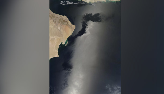
A new image shows what seems like the intrusion of darkness into light areas in this satellite image of the Arabaian Sea. The effect is an artifact of a natural phenomenon known as sunglint. Credit: Jeff Schmaltz/NASA
![]() May 3rd, 2017 | 10:15 AM |
May 3rd, 2017 | 10:15 AM | ![]() 1287 views
1287 views
SPACE.COM
The forces of darkness seem to be coalescing in the Arabian Sea in a spooky satellite image taken from space.
But the eerie supernatural effect, in which the tentacles of darkness seem to be intruding into regions of light, has a completely ordinary cause: normal weather patterns in the area.
The image was taken on April 11 using the Moderate Resolution Imaging Spectroradiometer aboard NASA's Terra satellite. When satellites gather light from above smooth waters, the light reflects upward like a mirror. But once water gets wavy, light hitting the water's surface reflects up toward the satellite at many different orientations — meaning less light reaches the satellite's photodetectors, according to NASA's Earth Observatory. When the sun, the satellite and the water are all aligned, the water appears much brighter. The phenomenon is known as sunglint, agency officials said.
When someone is looking at satellite images of Earth, sunglint typically appears as a streak of bright light that shows up in the middle of the satellite image. In this image, the sunglint appears most pronounced in the bottom central area of the image, which shows the Arabian Sea.
While some of the most spectacular examples of sunglint may appear in space photos, the phenomenon is also terrestrial: Anyone sitting on the beach who has looked out at a bright line of sunlight hitting the ocean has seen a similar process, known as a glitter path.
Source:
courtesy of SPACE
by Tia Ghose
If you have any stories or news that you would like to share with the global online community, please feel free to share it with us by contacting us directly at [email protected]
Today |
145114 |
Since March 25, 2016
![]()
![]()
![]()
![]()
![]()
© Copyright 1999 - 2024 | Brunei's No. 1 News Website. All Rights Reserved.
1250-A, Jalan Tanjung Bunut,Jalan Tutong BF2920, Bandar Seri Begawan, Negara Brunei Darussalam