![]()
![]()
![]()
![]()
![]()
![]()
![]()
![]()
![]() Home > Malaysia
Home > Malaysia
Penang Hill Getting Bad to Worse
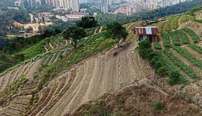
More brown, less green: Above the suburbs of Relau, with a view of Pulau Jerejak in the horizon, vegetable beds line the hilltop between Relau and Paya Terubong. | PHOTO: Se Vena Networks
![]() April 24th, 2016 | 07:55 AM |
April 24th, 2016 | 07:55 AM | ![]() 2702 views
2702 views
GEORGE TOWN, MALAYSIA
The clearing of land on Penang Hill is far more widespread than previously thought.
While some bald patches can be seen by the naked eye from the road at the bottom of the hill or by photographers using telephoto lenses, an aerial survey showed rampant hill clearings along the hill slope, especially in Paya Terubong.
The Star captured these images via a drone flying between 180m and 450m upwards from Jalan Paya Terubong.
The images revealed ugly hill slope clearings quite similar to that in Cameron Highlands and Lojing.
Those clearing the area are farmers who want to plant crops. They have also terraced the hill slopes.
Some of them own the land, some have temporary occupation licences while others may have cultivated the state land illegally.
There are some structures being erected on the hill slope above the cemetery in Paya Terubong.
A drone picture showed foreign workers doing construction work.
There was also a bald patch near a telecommunications tower, not far from the Kuan Yin Pavilion.
This can be seen clearly by motorists coming down from Lebuhraya Thean Teik near another cemetery heading to Bandar Baru Air Itam.
When the aerial pictures were shown to Penang Island City Council mayor Datuk Patahiyah Ismail and engineering department director Addenan Mohd Razali, Patahiyah said the council would issue a statement later.
“We are aware of the hill clearings. We have taken aerial pictures. Action is being taken,” she said.
However, when pressed, she did not elaborate on the type of action taken. Patahiyah said farmers were violating the Street, Drainage and Building Act 1974 if they had not obtained approval from the council first.
“If they disturb the soil for cultivation, they must apply for earthworks approval. This means they cannot clear the forest. It’s an offence,” she said.
On the buildings under construction along the slopes, Patahiyah said the council would need to check whether any plans for earthworks and building had been submitted.
Patahiyah said there must be a concerted approach by government departments to check on hill clearings.
“The council can only use the Street, Drainage and Building Act.
“We need the Lands and Mines Office and the district office to the National Land Code 1965 to investigate the hill clearings,” she said.
Asked whether the council had shared its aerial pictures with either the Lands and Mines Office or district office, Addenan said no.
“We keep them for own record. But we share the pictures with other departments in the council, such as the Building Department to check whether a particular structure had been built without permission.
“But if the Lands and Mines Office and district office want the pictures, we can share with them,” he said.
Addenan said the council would work with other departments such as the Survey and Mapping Department when taking enforcement action.
“We need to know the lot numbers of the land in question. We usually conduct site visits with several departments so as to get their input as well,” he said.
A Penang Agriculture Department spokesman said they did not encourage farmers to cultivate along steep slopes as this would cause soil erosion.
He added that they would report to the Land Office if they came across forest land which was suspected of being cleared illegally for cultivation.
“Farmers have been planting vegetables and other crops on the slope of Penang Hill from the time of colonial rule.
“There is nothing much we can do about it now,” he said, adding that they do not have enforcement powers.
“But when farmers request for aid, such as fertilisers or equipment, we will visit the farm and check whether the site is suitable. If it is on a steep hill slope, the request will be rejected,” he said.
Consumers Association of Penang president S.M. Mohd Idris was outraged after seeing the aerial pictures.
“It appears there is a free-for-all on Penang Hill. Farmers are still clearing hill slopes as they please despite the umpteen press statements by the authorities on action against hill clearings.
“Buildings are also being constructed on the slopes. Is the council doing anything about it? If they are aware, what action have they taken so far? he asked.
Idris said Penang island was famous for its hills and natural beauty but these were being destroyed.
In November last year, Chief Minister Lim Guan Eng had announced in the state assembly that the city council was using drones to check illegal land clearing.
He said the council also planned to install CCTVs to monitor illegal earthworks in hilly areas this year.
Lim said the council had identified 22 locations for the CCTVs.
Hilly areas that are not covered by CCTVs would be monitored using drones.
Source:
courtesy of THE STAR
by The Star
If you have any stories or news that you would like to share with the global online community, please feel free to share it with us by contacting us directly at [email protected]
Today |
325003 |
Since March 25, 2016
![]()
![]()
![]()
![]()
![]()
© Copyright 1999 - 2024 | Brunei's No. 1 News Website. All Rights Reserved.
1250-A, Jalan Tanjung Bunut,Jalan Tutong BF2920, Bandar Seri Begawan, Negara Brunei Darussalam