![]()
![]()
![]()
![]()
![]()
![]()
![]()
![]()
![]() Home > National
Home > National
14th Southeast Asia Survey Congress
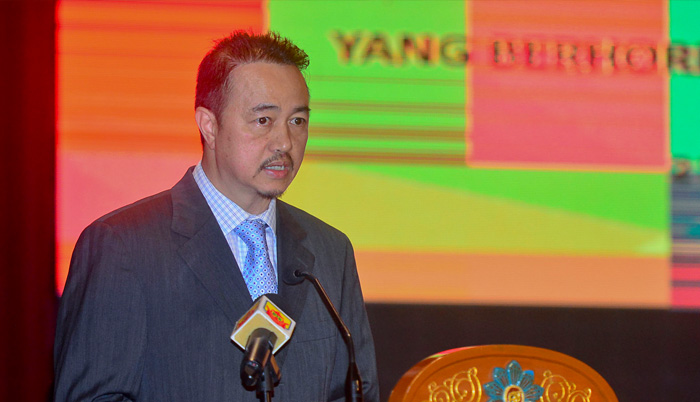
Yang berhormat Dato Seri Setia Awang Haji Bahrin bin Abdullah, the Minister of Development
![]() August 16th, 2017 | 08:49 AM |
August 16th, 2017 | 08:49 AM | ![]() 1333 views
1333 views
GADONG
Geospatial technologies are among the most important and exciting emergent technologies today and the dynamism in their growth and application offers the potential to reward adopters both in the private sector and in government. Thus, the increasing availability of Geographic Information Systems and Internet Mapping with high resolution Earth images is prompting private and public sector to start embracing and applying this technology in their planning, development and business strategies.
Yang berhormat Dato Seri Setia Awang Haji Bahrin bin Abdullah, the Minister of Development underlined the matter in his keynote address at 14th Southeast Asia Survey Congress, this morning.
The theme 'Bridging the Gap' is relevant with the ASEAN common aspiration and vision of an even more closely knit regional community with the aim to forge even closer cooperation in Land Surveying and Geomatics. During the congress, two plenary papers were delivered by Pengiran Matusin Bin Pengiran Matasan, the President of Brunei Institution of Geomatics (B.I.G) and Mr. See Seng Guan, Surbana Jurong Consultants Private Limited Company, Singapore.
Over 300 participants attended the congress comprising local government officers, student and international. Also present was Dato Seri Paduka Awang Haji Suhaimi bin Haji Gafar, the Deputy Minister of Development.
Source:
@BRUDIRECT.COM
by Brudirect.com
If you have any stories or news that you would like to share with the global online community, please feel free to share it with us by contacting us directly at [email protected]
Today |
97882 |
Since March 25, 2016
![]()
![]()
![]()
![]()
![]()
© Copyright 1999 - 2024 | Brunei's No. 1 News Website. All Rights Reserved.
1250-A, Jalan Tanjung Bunut,Jalan Tutong BF2920, Bandar Seri Begawan, Negara Brunei Darussalam