![]()
![]()
![]()
![]()
![]()
![]()
![]()
![]()
![]() Home > Philippines
Home > Philippines
‘Jenny’ Intensifies Into Typhoon; Signal No. 3 Possible In Some Areas
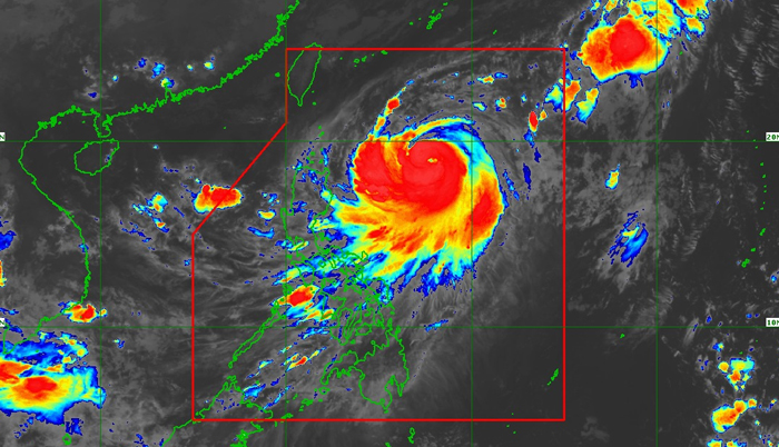
Satellite image of Typhoon Jenny (international name: Koinu)
![]() October 2nd, 2023 | 09:29 AM |
October 2nd, 2023 | 09:29 AM | ![]() 2700 views
2700 views
MANILA
Tropical cyclone Jenny (international name: “Koinu”) has become a typhoon while over the Philippine Sea on Monday, Oct. 2, said the Philippine Atmospheric, Geophysical and Astronomical Services Administration (PAGASA).
In its 5 a.m. bulletin, PAGASA said Jenny had maximum sustained winds of 120 kilometers per hour (kph) near the center and gusts of up to 150 kph.
It was last spotted 655 kilometers east of Aparri, Cagayan, and is moving northwestward at 10 kph.
Signal No. 1 up
Due to the anticipated onset of strong winds from Jenny, tropical cyclone wind signal number 1 was hoisted over Batanes, Babuyan Islands, the eastern portion of mainland Cagayan, and eastern portion of Isabela.
“The most likely highest wind signal that will be hoisted is wind signal number 2, although the potential for wind signal number 3 is not ruled out at this time,” PAGASA said.
Gusty conditions may also occur in some areas, without wind warnings due to the southwest monsoon, or “habagat.”
These may be experienced in Oriental Mindoro, Occidental Mindoro, Marinduque, Romblon, Palawan, Western Visayas, and Bicol on Monday; Metro Manila, Cavite, Laguna, Batangas, Rizal, Quezon, Oriental Mindoro, Occidental Mindoro, Marinduque, Romblon, Palawan, Bicol Region, and Western Visayas on Tuesday, Oct. 3; and in Bataan, the southern portion of Aurora, Metro Manila, Cavite, Laguna, Batangas, Rizal, Quezon, the northern portion of Palawan including Calamian Islands, Romblon, Occidental Mindoro, and portions of Bicol Region on Wednesday, Oct. 4.
Brace for heavy rains
PAGASA said Jenny may bring moderate to heavy rains over Batanes, Babuyan Islands, and the northern portion of mainland Cagayan until Tuesday.
On Wednesday, heavy to intense rains may prevail over Batanes, while moderate to heavy rains may persist in Babuyan Islands, Ilocos Norte, and the northern portions of mainland Cagayan and Apayao.
PAGASA said the typhoon-enhanced habagat may also bring occasional to monsoon rains over the western portions of Central and Southern Luzon, Visayas, and Mindanao in the next three days.
Likelihood of landfall ‘decreasing’
Jenny may continue to move northwestward until Tuesday before turning west-northwestward or westward in the next few days.
“On the track forecast, Jenny will make landfall over the southern portion of Taiwan on Thursday afternoon or evening (Oct. 5), then exit the Philippine area of responsibility (PAR) over the Taiwan Strait between Thursday evening or Friday morning (Oct. 6),” PAGASA said.
“A landfall or close approach scenario over the Batanes area is still not ruled out, although the likelihood is decreasing,” it pointed out.
PAGASA said Jenny may intensify steadily throughout the forecast period.
It may reach its peak intensity on Tuesday, then a gradual weakening trend by mid-Wednesday “due to a potential for dry air entrainment and increased wind shear prior to landfall over Taiwan.”
Source:
courtesy of MANILA BULLETIN
by ELLALYN DE VERA-RUIZ
If you have any stories or news that you would like to share with the global online community, please feel free to share it with us by contacting us directly at [email protected]
Today |
252499 |
Since March 25, 2016
![]()
![]()
![]()
![]()
![]()
© Copyright 1999 - 2024 | Brunei's No. 1 News Website. All Rights Reserved.
1250-A, Jalan Tanjung Bunut,Jalan Tutong BF2920, Bandar Seri Begawan, Negara Brunei Darussalam