![]()
![]()
![]()
![]()
![]()
![]()
![]()
![]()
![]() Home > Space & Science
Home > Space & Science
See Tropical Storm Colin From Space In These Satellite Photos
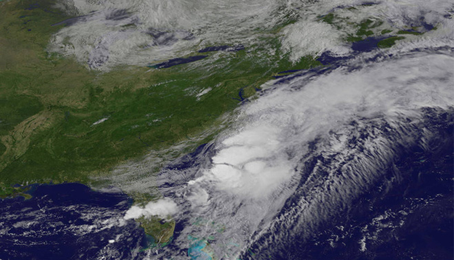
This visible-light image, captured by NOAA’s GOES-East satellite, shows that the bulk of the former tropical storm Colin's clouds had already moved into the Atlantic Ocean by June 7 at 9:30 a.m. EDT (1330 GMT).
![]() June 8th, 2016 | 08:36 AM |
June 8th, 2016 | 08:36 AM | ![]() 1634 views
1634 views
Space
New satellite photos show the former Tropical Storm Colin surging across Florida and into the Atlantic Ocean this morning (June 7).
Colin churned northeast through the Gulf of Mexico before making landfall in Florida's "Big Bend" region late Monday night (June 6). The storm soon popped free into the Atlantic, and by 8 a.m. EDT (1200 GMT) today, Colin was about 45 miles (75 kilometers) south of Wilmington, North Carolina, NASA officials said.
The storm's progress has been tracked by a number of Earth-observing satellites, including NASA's Terra and Aqua spacecraft and the National Oceanic and Atmospheric Administration's (NOAA) GOES-East satellite.
Terra and GOES-East captured detailed visible-light imagery of Colin, while Aqua gathered infrared data showing that the maelstrom hosts strong thunderstorms, NASA officials said.
According to the latest update from NOAA's National Hurricane Center (NHC) in Miami, which was published at 5 p.m. EDT (2100 GMT) today, Colin is moving northeast at about 40 mph (65 km/h), with maximum sustained winds near 60 mph (97 km/h).
"This general motion is expected to continue through Wednesday night," the update reads. "Some slight strengthening is possible today and tonight, but gradual weakening is expected to begin on Wednesday."
The storm is expected to bring 1 to 2 inches (2.5 to 5 centimeters) of additional rainfall to far-eastern North Carolina through this evening, and 1 to 3 extra inches (2.5 to 7.5 cm) of rain across central Florida during the same period, according to previous NHC updates. Some parts of Florida, however, could receive up to 5 inches (12.5 cm) of additional rainfall.
Colin was classified as a tropical storm while in the Gulf of Mexico and cruising across Florida, but it was downgraded to a post-tropical cyclone shortly after moving into the Atlantic Ocean. (Post-tropical cyclones no longer have "sufficient tropical characteristics" to be considered tropical storms, NOAA officials have said.)
Colin never reached the status of hurricane, a term used for intense tropical cyclones with maximum sustained winds of at least 74 mph (119 km/h).
Source:
courtesy of SPACE
by Mike Wall
If you have any stories or news that you would like to share with the global online community, please feel free to share it with us by contacting us directly at [email protected]
Today |
426289 |
Since March 25, 2016
![]()
![]()
![]()
![]()
![]()
© Copyright 1999 - 2024 | Brunei's No. 1 News Website. All Rights Reserved.
1250-A, Jalan Tanjung Bunut,Jalan Tutong BF2920, Bandar Seri Begawan, Negara Brunei Darussalam