![]()
![]()
![]()
![]()
![]()
![]()
![]()
![]()
![]() Home > Space & Science
Home > Space & Science
NASA Climate Change Satellite Back Online After Instrument Shutdown
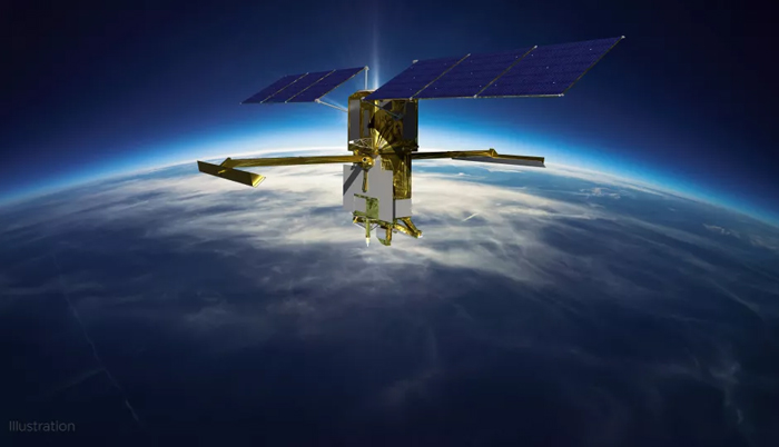
Artist's illustration of the Surface Water and Ocean Topography (SWOT) satellite in Earth orbit. (Image credit: CNES)
![]() March 21st, 2023 | 10:07 AM |
March 21st, 2023 | 10:07 AM | ![]() 253 views
253 views
WASHINGTON, UNITED STATES
A stricken Surface Water and Ocean Topography (SWOT) instrument is back online, but NASA officials did not disclose a cause for the issue during commissioning.
A multi-agency mission seeking to map Earth's water in incredible detail is back on track with commissioning following an instrument issue.
NASA and the French space agency (CNES) found a solution to turn on the Surface Water and Ocean Topography (SWOT) satellite's main science instrument. The instrument, called KARIN (Ka-band Radar Interferometer), shut down suddenly in late January.
The team elected to use a backup power unit to get KARIN working, NASA said in a Friday (March 17) update. "The backup unit was chosen to expedite the restoration of operations and to minimize overall risk to the mission," officials wrote in a blog post(opens in new tab).
NASA officials did not disclose a cause for the issue for the instrument, which is the keystone sensor behind SWOT's mission to map surface water to see how climate change affects Earth's water levels.
KARIN is a system of two antennas spaced about 33 feet (10 meters) apart, which is equivalent to half the length of a tennis court. It is designed to generate radar pulses from one of the antennas and then to receive signals with the two antennas working together.
SWOT is expected to begin science operations in July, NASA officials confirmed on Friday, which is about on track with original estimates.
SWOT launched from Vandenberg Space Force Base in California on Dec. 16, 2022 aboard a SpaceX Falcon 9 rocket. Once ready, the multi-agency mission will assess and monitor global water levels to better learn how carbon dioxide, a greenhouse gas, influences rising water influenced by global warming.
The mission will scrutinize 1.3 million miles (2.1 million km) of rivers, along with coastlines and lakes. NASA will also make the information publicly available and provide tools for communities to track their own water levels locally.
Source:
courtesy of SPACE
by Elizabeth Howell
If you have any stories or news that you would like to share with the global online community, please feel free to share it with us by contacting us directly at [email protected]
Today |
126958 |
Since March 25, 2016
![]()
![]()
![]()
![]()
![]()
© Copyright 1999 - 2024 | Brunei's No. 1 News Website. All Rights Reserved.
1250-A, Jalan Tanjung Bunut,Jalan Tutong BF2920, Bandar Seri Begawan, Negara Brunei Darussalam